
Hiking Mount Katahdin: A Family Adventure in Maine

Updated: Sep 8

Mount Katahdin is Maine's highest mountain at 5,269 feet. Hiking it requires an elevation gain of over 4,000 feet. This makes for an extremely strenuous climb, but the views are spectacular. Located within the 209,644-acre untouched wilderness of Baxter State Park, Katahdin is well known as the northern terminus of the 2,190-mile Appalachian Trail, which starts in Georgia. Named by the Penobscot Tribe, Katahdin translates to "The Greatest Mountain." It is viewed as a spiritual center where earth and sky converge.
Trailheads to the Summit
There are many routes up this massive mountain, with three main trailheads:
Katahdin Stream Campground - Hunt Trail
Abol Campground - Abol Trail
Roaring Brook Campground - Chimney Pond, Saddle Trail, Knife's Edge, Heylon Taylor Trail
Campgrounds are located at each trailhead. Sleeping in the park the night before ensures access to the trail. Those who don't stay in the park must get a Katahdin Trailhead Pass (KTP). This is a fancy term for a day-use parking reservation. The pass can be reserved on Baxter State Park's website and costs $10 per day.
Important Information About Katahdin Trailhead Passes (KTPs)
KTPs are limited. If you have one, you must arrive at the Togue Pond gatehouse before 7:00 AM on the day of your hike for it to be valid. After 7:00 AM, KTPs are released to those waiting in the first-come, first-served parking line. But it’s not as stressful or complicated as it sounds, especially if you have a Maine license plate.
Campground reservations at Baxter State Park open four months in advance. I booked ours back in May: two nights in a lean-to at Katahdin Stream, securing our hike. A family emergency forced a change of plans, and we ended up staying just one night before the hike in a cabin at the New England Outdoor Center (NOEC). This meant trading the lean-to reservation for a KTP on the day of our hike, which we managed to get—thanks to Maine plates and a bit of luck. Since the NEOC is only 20 minutes from the Togue Pond Gate, we still made it in well before 7:00 AM. When I flashed our KTP to the park ranger upon arrival, he smiled.
"Ah, a golden ticket. Drive on past the standby line to the main gate."
So drive we did, passing at least 25 cars waiting and hoping for a parking spot at a trailhead that day. And it was only 6:30 AM.
Choosing the Right Trail
We chose to summit Katahdin's Baxter Peak (the main and highest peak) via Hunt Trail. This was where we originally had a campsite, and I knew it was a popular route. What I hadn't done was enough research. The popular route, as it turns out, is to hike up Hunt Trail and down Abol Trail. Not down Hunt Trail the way we did.
The reason became clear on our descent. We cautiously made our way down steep boulder fields with vertical drops on either side. It was a far more technical climb going down than up. These pictures help illustrate the point, but multiply the fear factor by 1,000 for the real-life experience.
Side note: My husband and I are both afraid of heights, so there's a chance I'm blowing this out of proportion, but I really don't think so.

From the easy start of the Hunt Trail, winding through dense forest, you'd never imagine the trail leading to a pile of massive boulders. Or the flat, exposed section after that, just before the final push to the summit. The terrain changes drastically throughout this route.

I've always found it funny that most hikers share photos of the sign at Katahdin's summit, but rarely the view from it. So here it is, in all its glory.

And here's a view of Knife's Edge from the summit. We did not choose this route because, again, of our fear of heights. This trail would have us crawling across it and embarrassing our teenagers.

Instead, we decided to punish ourselves with a cortisol-spiking climb down Hunt Trail. It features relentless boulders, vertical drops, iron rungs, and technical rock scrambles—all while looking down over cliffs that drop off for miles.
The relief Tim and I felt after making it through the final section of boulders was the reward. Still, our legs were so tired after 7 hours of gnarly climbing that one of us (I won't name names) went down like a 6-foot-2 tree trunk on the last easy mile, tripped up by a tiny root.
But our boys were unscathed. Finn, the light-footed mountain goat, hopped from rock to rock, making it through the boulder sections so effortlessly that we found him waiting patiently on the other side. Henry, who used to be afraid of heights, has been spending his time rock climbing at Evo Rock and Fitness. He loved using his skills in a natural setting. Between that and the stunning landscape for photography, this hike was the "highlight of his summer."
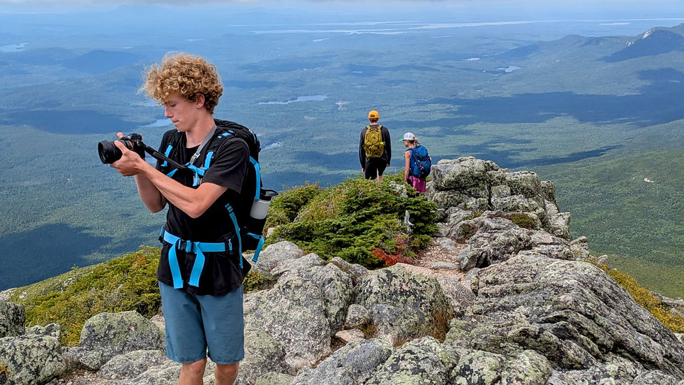
Because our boys loved Hunt Trail, I don't regret going up and down it. However, I feel the need to warn you if you plan to hike Katahdin and follow this route. If you're afraid of heights, take Abol down. Or better yet, take Chimney Pond to the Saddle Trail. This route is wide and gradual, avoiding the steep and terrifying drop-offs found on Hunt, Abol, and most other routes.
Preparing for Your Hike
Whichever path you choose, pack plenty of water and snacks. It’s a full day of climbing! In total, we hiked 9.33 miles in 7.25 hours with an elevation gain of 4,177 feet. This was much faster than I usually hike, but my boys (all three) have long legs and tend to move full speed ahead.
Exploring More Trails
If you're looking for smaller hikes in Baxter State Park, there are endless options! Reach out if you need suggestions. Enjoy your adventure in Maine's most gorgeous wilderness destination!


