Boulder Loop Trail near Conway, NH
- Jill McMahon
- Mar 16, 2025
- 4 min read
Updated: Mar 18, 2025

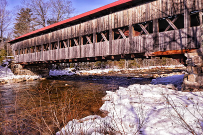
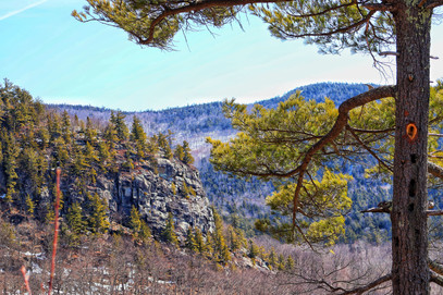
This moderate 3.5-mile loop is located off the Kancamagus Highway near Conway, NH. The trail begins with a walk through the historic Albany Covered Bridge, then follows a loop filled with glacial erratics, steep rock walls, scenic views of the Passaconaway Valley, and peaceful pine forest. The giant boulders scattered along the path were transported here by glaciers and left in remarkable spots. It's a great hike for kids, who will have fun climbing on and around the massive rocks and caves.


The Boulder Loop was not the hike we had originally planned. But plans are sometimes foiled, often leading to a new option that is even better than the first. My initial idea was to hike South Moat Mountain near Conway, and my husband Tim and son Henry decided to join me. This was a pleasant surprise since Tim is a self-proclaimed "indoor cat" during winter and usually only joins my outdoor adventures in the warmer months. I was excited they were coming and eager to show them the stunning open summit of South Moat.
March may be the worst month for mountain climbs, but due to deadlines for the guide I'm working on, hiking during this season of mud, ice, and post-holing in melting snow was unavoidable. To offset the likely crappy hiking conditions, I focused on good food, waking up at 4:30 am to pack plenty of delicious snacks and cook a hearty breakfast for my family. The weather forecast promised sunshine, and I was prepared for a great day in the mountains.
The drive was easy enough, but when Google Maps announced, "You have arrived," we were nowhere near the trailhead. GPS hadn't accounted for the road closure on Passaconoway, where the trailhead parking was located. Instead, it directed me to the shoulder of Route 112, and from there, a dotted line crossing the Swift River, then bushwacking to the trailhead on the other side. I did get out of our car to see if crossing the river was possible, but thanks to my voice of reason (Tim), we decided to keep driving. If the name "Swift River" doesn't explain this decision, here's a photo of it.

I was frustrated with myself for not checking the Google map in advance and disappointed that we couldn't reach the glorious summit I'd envisioned my family enjoying. This left me with two choices:
Beat myself up, throw a giant baby tantrum, and return home in tears.
Take a deep breath, show myself some kindness, and focus on finding another hike.
I considered option one, but went with option two. Henry was watching me and I wanted to model patience with our mistakes, which are an inevitable part of life and usually have something to teach us. I also know from countless experiences that when one door closes, another opens. I knew we'd find another hike with my reliable All Trails app.
And that was the very moment Tim and I lost cell service, making it impossible to use All Trails. So we drove...and soon found ourselves in a parking lot near a covered bridge. We decided to check out the bridge and let Romy walk. On the other side of the bridge was a trailhead for the Boulder Loop Trail, which we decided to explore.


Four miles and three hours later, we'd filled our buckets with mountain views, sunlit forests and quiet trails all to ourselves. In hindsight, South Moat Mountain was too ambitious given the March conditions, Henry's frequent stops to use his new camera, and Romy's extra winter weight. We ended up with the hike we were meant to do, and South Moat will still be there once the snow melts.
Now I will share details on this incredible, surprise hike we never knew we wanted. As always, things have a way of working out.

The Boulder Loop Trailhead is located off of Passaconaway Rd in Albany, but if you visit during the winter months, you will park in the lot off Route 112 (Kancamagus Highway) due to road closures on Passaconaway. There is plenty of parking here and a $5 fee at the trailhead.
Cross the picturesque Albany Covered Bridge over the Swift River, then take a right to follow Passaconaway Rd a short distance to the start of the Boulder Loop on the left. I recommend following the loop clockwise to see the most impressive of the giant glacial erratics at the beginning of your hike.
There are some steep sections on this hike, but it's doable for young kids and all kinds of dogs. For a shorter hike with less elevation than most in the White Mountains, this climb offers some spectacular clifftop views and vistas of surrounding mountains.


What I loved most about this hike was the way pine needles neatly covered the trail almost the entire way. I've never seen anything like it, and I'm still baffled as to how it occurred naturally. I imagined little wood elves with tiny trucks spreading pine needles along the path to prevent anyone from getting lost. This unique feature of the hike remains a mystery to me.


These tranquil woods, with sunlight streaming through the trees, provided Henry with the ideal setting to use his newly purchased camera. We took our sweet time, allowing him to photograph the tiny details of this gorgeous hike. In the end, the hike took us three hours and was four miles in length.
I realized that this smaller hike allowed us the time and leisure we were all looking for after a long work and school week in March. We didn't get the hike we'd planned on, but we got the hike we needed.